- The main tar road north to Lower Sabie (H4-2)
- Towards the Lebombo area (S28) in an easterly direction
- Going in a western direction on the Crocodile River Road into Biyamati (S25)
- On a northerly route with the H4-1 going to Skukuza, via the Randspruit Road (H5)
Crocodile Bridge Gate is the most eastern entrance to Kruger National Park. Crocodile Bridge Gate can be entered in from the N4 road. The N4 travels along Nelspruit and Malelane into Komatiepoort. It is one of the hottest areas, going over 40 degrees C (104 degrees F) in summer. It's also in close proximity to the border gate between South Africa and Mozambique.
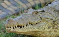
Crocodile Bridge Gate is named after the Crocodile River. For those who are heading into the south-eastern section of the Park, Crocodile Bridge is the most direct way of doing so. With Crocodile Bridge having a high concentration of game, wildlife viewing opportunities are high and exciting.A short distance from the gate, you will find Crocodile Bridge Rest Camp - equipped with a petrol (gas) station, essentials and food. Please note that this camp usually floods during heavy rainfall.
A highlight is that Crocodile Bridge is Rhino territory, the white Rhino is often seen in mixed woodland while the shy black Rhino stays deep in the thorn thickets.Wildlife Rhythms
Predators to look out for in this area, is Lion, Spotted Hyena, Leopard, Cheetah and Wild Dog. Some of the grazers and browsers include Impala, white and black Rhino and Hippo.Crocodile Bridge towards Lebombo (S28)
Originally in the 19th century, Nhlowa Road (S28) was the main track to the Sabie Game Reserve from Crocodile Bridge Gate. The road turns north-east to the entrance gate facing the Lebombo Range which creates the border with Mozambique.The landscape is dominated by Knob Thorn Acacia and Marula trees. The landscape is usually flat with very few features compared to the rest of the southern region. However, it's good for game because of the good grazing opportunities.You will notice that the vegetation gets less and less as you approach the Lebombo Mountain Range. Like much of southern Kruger, this is also a good area for white Rhino and the blackbreasted snake eagle.The road is the access route to the Mpanamana Concession, named after the Mpanamana River and Dam which feeds into the Crocodile River. The S28 can also leads into the H4-2 further north which takes you to Lower Sabie Rest Camp.
Crocodile Bridge Main Road to Lower Sabie Camp (H4-2)
The northern area between Crocodile Bridge and Lower Sabie (H 10) offers some of the best wildlife viewing. A real treat is the Cheetah viewing available. This area is made up of open savannah grassland on basalt - sweet, nutritious, grazing on open plains, which is very good for Cheetah. Cheetah prefer a flat zone to help them move fast in pursuit of prey.The Gomondwane Road to Lower Sabie (H4-2) follows the Vurhami River. The 2 waterholes in the area are Gezamtombi and Gomondwane (water is fed into Gomondwane). Waterholes are the perfect spots to see game, because all the animals will need a drink of water at some point. While you enjoy the lovely views of the bush you can see a variety of herbivores.
As you approach Lower Sabie Camp, you will see the Lebombo Mountain Range to the east and Muntshe Mountain (435m) right in front of you (a lot of Zebra and Wildebeest can be found here). The road takes one right to the Sabie River; you will know you are at the camp which is distinguished by a wide riverbed environment.
Originally this road was the path which connected Chief Magashula's kraal (home) at Phabeni to Delagoa Bay. One of the Kruger National Park's first traders (Jaoa Albasini) from Portugal had a store along this road.
The southern part of the Kruger National Park has a history that can be traced back centuries. Attractions and sightseeing activities include the San (Bushmen) paintings which adorn an overhanging sandstone rock near the Hippo pool, the only remnants of the San People who once lived and hunted in this area.
Not only does this area have a great variety of game, it has a very high density of Hyena. The game viewing area is known as the 'Southern Circle', famous for its concentration of Lion prides with different hunting techniques and behaviour. The area between Crocodile Bridge and Lower Sabie is one of the best areas in Kruger to try and see the Big Five.
Crocodile River Road (S25)
The Crocodile River Road (S25) faces a westerly direction into thick thorn bush and grassland, with the choice of going through the central part of the southern Park - Bume Road (S26) into the Biyamiti Loop (S23), or to follow Crocodile River towards Malelane. The S25 will take you past some historical sites. If you turn right at the end of the S25 onto the S114, you can make your way to the Jock of the Bushveld plaque.
The first exit from the road is Hippo Pools (S27) which is 8kms from the gate. On Crocodile River Road you will get a chance to see Hippo, Crocodile and the game getting a drink of water. Crocodile River Road is very good to for sightings of wildlife, Martial Eagle and other raptors.
Crocodile River Road is very well known for its game sightings. Due to this, the traffic can get very busy. It's best to start your travels early and work out an alternative route when you come back in the afternoon. Remember the best sightings are early in the morning and late in the afternoon.
Crocodile River Route (S114-S25)
Turning right from Malelane on the Crocodile River Road (S114), a bird hide is available at Gardenia on the Mlambane Loop (S118).
On this road is the old crossing point on the Crocodile River and the site where a Alf Roberts had his trading store in the late 1800s. It was in this vicinity that Boer general Ben Viljoen deserted his artillery during the Anglo-Boar War at the beginning of the 20th century.
The highlight of this road, aside from the riverine forest, are the several ecosystems, starting from the Malelane Mountain Bushveld through mixed bushwillow into the Sabie Crocodile thorn thickets and finally into the Delagoa thorn thickets. The Crocodile River Road is the southern boundary of the Lwakahle.
 Map of Crocodile Bridge Route in Kruger National Park...
 Just a stone's throw from the Mozambican border and Maputo, Crocodile Bridge Camp is rich in local history and is the best half-way house yo...