About Southern Mopaneveld
Engelhard Dam
Letaba Area
Letaba Camp to Mozambique
Letaba to Mopani
Letaba to Olifants
Olifants Area
Palaborwa Gate Area
Phalaborwa to Letaba
Phalaborwa to Mopani
See Kruger Park Olifants Area Self-drive Map

In the Olifants area look out for
Animals
Elephant
Lion
Hippo
Crocodile
Baboon
Birds
Martial eagle
Green-backed heron
Trumpeter hornbill
Black stork
Red-winged starling
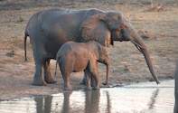
Around the Olifants rugged veld are a number of other ecosystems - the stunted knob-thorn savanna to the south, the Lebombo to the east and north, mopaneveld to the north-west and mixed bushwillow woodlands to the west. As the name suggests, this terrain is favoured by elephants, which are attracted by the wide variety of trees.
There are usually more browsers than grazers in the Olifants rugged veld, and herd numbers are considerably lower than they are in the more open grasslands. Baboons and vervet monkeys are well adapted to this environment and hang out regularly around Olifants and Balule Camps. Listen out at night for the thick-tailed bushbaby which has a piercing, haunting cry.

River that divides the north from the south
The Olifants (Afrikaans for "elephant") River is a major dividing line between the north and the south of Kruger. To the north is mopaneveld, to the south the bushwillow and acacia species dominate.
The earliest recorded use of the name is from 1869 when pioneer map-maker Vincent Whitshed Erskine referred to it as the "Oliphants".
Previously the Olifants had a wide variety of names, including the Lepelle (Sotho) and Rimbelule (Shangaan).

Ngotso Pan is one of the best places in Kruger to get close-up photographs of hippo. The car park comes right to the edge of the water hole where hippo often cavort. Hippo once occupied every river in Africa but are now confined generally to game reserves.
The water hole at Bangu on the Old Main Road to Satara (S90) is worth visiting as giraffe, zebra, impala and buffalo often congregate here. From this point northwards, giraffe become less common as the acacia-veld gives way to mopane. Acacia is the preferred diet of the giraffe and they are absent from most of the mopaneveld, with herds in the north concentrated mostly in the sandveld around Punda and Pafuri.
The S90 follows the Bangu drainage system through sweeping knob-thorn savanna grasslands. There are usually few other vehicles on this road so one has a real sense of isolation in the wilderness with views well into the distance. Game viewing in the north is always unpredictable, but there are often large herds of animals on the S90.
Olifants Rest Camp

Olifants Rest Camp is wonderfully situated on a high ridge overlooking the Olifants River about 10km upstream from its confluence with the Letaba. There are invariably elephants, hippos and crocs on the sandy river banks.
The camp, which has dramatic views out over the mixed woodlands and the Lebombo Mountains, is well-positioned as a game-viewing camp because it sits between two river systems - the Letaba and Olifants - and three ecozones - the Olifants rugged veld to the south, which consists of knob-thorn and bushwillow in open grasslands, mopane shrubveld to the north and the rocky Lebombo foothills to the east.
The varied habitat lends itself to a diversity of animals. Olifants has a good reputation as a birder's camp - the density and diversity of the woodlands and the availability of water attract a lot of birds, while there are often great raptor sightings from the lookout deck as birds of prey - such as the martial eagle - use the thermal updrafts of the steep hill to get their "lift" into the skies.
The Olifants area is also famed for its trees. Lowveld cluster-leaf, raisin bush and mopane are common in the woodlands which, in spring, become very colourful with the emergence of the bright yellow flowers of the long-tail cassia which contrast with the weeping boer-bean's striking red flowers.
There are a variety of rare aloes at Olifants, and the only accessible sesame bush in the whole of the Kruger Park grows just next to the petrol station. Olifants has a day visitors' picnic site with a swimming pool.
 Guests to Olifants Rest Camp will be exposed to an unforgettable window of Africa at their Kruger Park accommodation and lodging. The Olifan...
 Olifants consists of 3 eco systems so game viewing is excellent. There is also a high population of Elephant in the area. Olifants Camp offe...