About Southern Mopaneveld
Engelhard Dam
Letaba Area
Letaba Camp to Mozambique
Letaba to Mopani
Letaba to Olifants
Olifants Area
Palaborwa Gate Area
Phalaborwa to Letaba
Phalaborwa to Mopani
See Kruger Park Olifants Area Self-drive Map
There are three main routes between Tshokwane and Satara - the main Satara tar road (H1-3), the Lindanda (S35) and Trichardt Roads (S37) via N'wanetsi and the Nhlanguleni Road (S36).
The Main Satara Road (H1-3)
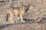
The H1-3 crosses 44km of open veld past a series of pans into the central grasslands. A number of watercourses make their way past Tshokwane, although the lack of reliable water has prevented its development into an overnight camp. Tshokwane marks the beginning of the lion territory associated with Satara and the central Park.Just north of Tshokwane is the Vutomi Loop (S34) which follows the Munywini River to the west before joining up with the Vutomi Road (S33), which follows the Ripape River back to the main Satara Road. This road is renowned for its lion sightings and the Vutomi Water Hole is often a good giraffe viewing spot. The area around Tshokwane is also associated with sightings of "white" animals - the most recent being a white lion and a white kudu seen during the mid-1980s.The Ripape area was an important winter grazing ground for thousands of zebra and wildebeest that used to migrate westwards in summer into what is now the greater Sabi Sand Reserve. According to Kruger historians Kloppers and Bornman, the erection of Kruger's western fence in 1961 disrupted this east-west migration path, causing the death of thousands of animals. Zebra and wildebeest died en masse in 1962 along the fence line, trying to get back into Kruger.The tragedy was exacerbated by a fire that year that destroyed most of the grassland between Nhlanguleni and the Sand River, causing the death of many of the grazers inside the Park. This migration instinct disappeared during the three decades the fence remained up.
It was taken down in the 1990s, allowing a free flow of animals between southern central Kruger and the private reserves, but time will tell whether the centuries-old migration pattern will re-emerge. The Ripape and Vutomi areas remain important winter grazing areas but zebra and wildebeest appear to move to the south-east of Kruger for their summer grazing.
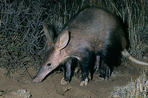
Aardvark
Aardvarks (Xomboni in Shangaan) are pig-sized nocturnal insect-eaters found throughout Kruger where there are swathes of termite mounds. Their burrowing claws and 30-cm tongue are perfectly adapted to their food needs of ants, termites and other insects.
They roam up to 15km a night looking for food and hole up in burrows during the day. Former Kruger Information Officer and author, PF Fourie says aardvarks don't come out of their holes easily.
He had the "very rare privilege of watching a 130-kg man, well known for his strength, trying to pull an aardvark out of its burrow when it was not more than half-way in. Needless to say, he made no impression on the aardvark".
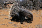
The H1-3 follows the N'waswitsontso watercourse for 20km from Tshokwane through prime lion territory. This is generally a good game drive because the grazing in this part of Kruger is particularly nutritious due to the underlying gabbro and basalt. In summer the pans along the watercourse fill up quickly after the rains. Late morning is a good time to stop off at Mazithi and other water holes as this is the time grazers like to drink. A few kilometres north is N'watinungu, "creek of the porcupines" in Shangaan.
The four-kilometre N'waswitsontso Loop (S86) is a highly recommended detour off the main road as there are often predators lurking in the riverine bush. Further north on the H1-3 is the southernmost baobab in Kruger. Baobabs are common north of the Tropic of Capricorn, but their range does not extend much further south. Another indicator of northern vegetation is the predominance of palm trees along the Sweni watercourse shortly before Satara.The Lindanda Road (S35)
The Lindanda Road edges past the N'wamuriwa Hill on the edge of the Lebombo, and crosses the eastern grasslands until it joins up with the Trichardt Road (S37) which heads north to N'wanetsi Picnic Site. The Metsi-Metsi Wilderness walking trail base camp is on the eastern side of N'wamuriwa, which has one of the most beautiful views over the central grasslands and Lebombo.
The hill often attracts lightning strikes, which are a natural cause of veld fires. After a thunderstorm, rangers regularly use the top of the hill to check the area for fires.
Lindanda was the Swazi nickname of ranger Harry Wolhuter, and referred to the cloth wrap he used to wear around his waist. It was on this road, close to the confluence of the Metsi-Metsi and Banyini streams, that Wolhuter had his near-death experience with a lion. It is fascinating to see the stone cairns that mark the distance he was dragged by the lion that knocked him off his horse, before he managed to kill it and free himself.
The Trichardt Road to N'wanetsi (S37)
The Lindanda Road (S35) joins the Trichardt Road (S37) which follows the path taken by the ill-fated voortrekker expedition of Louis Trichardt, who led a breakaway group of 53 voortrekkers from the interior plateau on a mission to reach the coast to establish ties with the colonial authorities in Portuguese East Africa.
From a game perspective, the S37 can be rewarding as it takes one through the flattish, stunted knob-thorn and marula grasslands favoured by the large herds of grazers. However, on a bad day one may see virtually nothing but grass, scrub and sky.
 Satara Rest Camp is the Kruger National Park's third biggest rest camp, providing a range of Kruger National Park accommodation. Satara is o...