About the South East
Crocodile Bridge Gate
Crocodile Bridge to Lower Sabie
Crocodile Bridge to Malelane
Crocodile Bridge to Skukuza
Lower Sabie Nhlowa Road
Lower Sabie to Skukuza
Lower Sabie to Tshokwane
The Biyamiti Area
See a map of South East Kruger Park
Lower Sabie to Skukuza via Nkuhlu (H4-1)

The Sabie River's name is derived from the Swazi word "sabisa" which means "to be careful" - apparently in reference to crossing the river because of the slippery rocks and resident population of crocodiles. The Lower Sabie Road (H4-1) to Skukuza is a particularly scenic drive that closely follows the Sabie River through riverine forest and thornveld.
There are two main routes between Lower Sabie and Skukuza - the main road via Nkuhlu picnic site (H4-1) and the Salitje road (S30) which is accessed off the S128.
This is one of the Park's most popular routes, and the volume of tourist traffic has earned it the nickname of "Piccadilly Circus". Although the distance between the two camps is only 43km, one should allow two-and-a-half hours for the drive because of the number of stops one is likely to make along the way. The fact that the road straddles several ecozones ensures there is an interesting mixture of grazers and browsers, while there are inevitably baboon and vervet monkeys in and under the tamboti and fig trees along the river banks.

In Lower Sabie look out for
Animals
- White rhino
- Hippo
- Lion
- Waterbuck
- Giraffe
Birds
- Giant kingfisher
- Goliath heron
- Brown snake-eagle
- African jacana
- Burchell's coucal
North of Lower Sabie are extensive grasslands with sweet grazing. This is one of the best places in Kruger to see the larger herds of zebra and wildebeest. There is an odd geological appearance of Clarens sandstone at the Lubyelubye stream crossing, which is believed to take its name from the Shangaan word labya which means "to go through the water wearing one's clothes".
North of the Lubyelubye stream crossing thorn thickets begin to dominate and the bush becomes denser. The road is excellent for birding and one should keep a sharp eye out for leopards as the chance of seeing them along the Sabie is better than almost anywhere else in the Park.
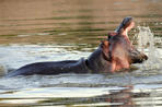
Hippo - one of Africa's most dangerous animals Their rage can be directed at other hippos infringing on their territory or against any foreign intruder, particularly humans. Several hippo deaths have been recorded in Kruger. The biggest hippo (mpfubu in Shangaan, imvubu in siSwati) recorded in Kruger was a bull weighing in at just over two tons. Most male hippos weigh about one-and-a-half tons. Nonetheless, they are surprisingly fast - they can outrun humans, clocking up a top speed of about 30km/h.
Hippos eat up to 100kg of grass in a 24-hour period. They feed mostly at night, spending their days in water. It's believed that hippos can remain under water for up to six minutes before surfacing for air, although most submersions are usually not longer than a couple of minutes. Hippos are old Africa. They have been around for 60 million years, having evolved from a pig-like animal during the Palaeocene era.
A recommended detour is the three-kilometre N'watimhiri causeway (S79) at the point where the stream of the same name joins the Lower Sabie. There are often elephant and buffalo crossing the road to get to the river. N'watimhiri means "creek of the puffadders" as these fat, venomous snakes are particularly common in this area, occasionally lying in pathways at sunset to get the last heat of the day. Shortly before Nkuhlu, the road crosses the N'watin'wambu watercourse which is an elephant route between the woodlands south of Skukuza and the Sabie River.
Nkuhlu (the Swazi name for the Natal Mahogany, Trichilia emetica) Picnic Spot is about halfway between Lower Sabie and Skukuza. One can do worse than stop for a braai on the slopes overlooking the river, especially if one is a keen birder. There is a shop and fast-food outlet at Nkuhlu.
The Lebombo - rugged hills of the eastern frontier
The Lebombo range is a stony and rugged series of rhyolitic hills that form the border between Kruger and Mozambique. These pink-hued ridges were formed by volcanic eruptions some 200 million years ago. This is one of the lowest rainfall areas in Kruger, and this is reflected in the vegetation types.
These are, the drought-resistant bushwillow species and the succulent euphorbias are common on the ridges where there are concentrations of Lebombo ironwood. Between the koppies are deep gorges that have their own ecosystems. The dark clay drainage lines support round-leaved bloodwood, marula and knob-thorn acacias. The Lebombo extends south beyond Kruger and forms the border of Swaziland and Mozambique and then Swaziland and South Africa.
In the extreme southern Lebombo is Border Cave which is the oldest known burial site in the world, dating back some 80 000 years. It was here that the world's oldest known mathematical instrument - the 37 000-year-old Lebombo bone - was found in the 1970s. The bone - a baboon fibula - has 29 distinct notches on it and may have been used as a lunar phase counter as it resembles the calendar sticks used by the San in Namibia. Approximately 100 million years ago the Indian Ocean extended to the foot of the Lebombo.
 From Lower Sabie Camp you have the opportunity to watch the endless procession of animals coming to drink at the Sabie River. Visitors canno...
 Skukuza Rest Camp in Kruger National Park is a popular rest camp situated in the heart of Kruger Park. Many visitors think Skukuza Rest Camp...