About the South East
Crocodile Bridge Gate
Crocodile Bridge to Lower Sabie
Crocodile Bridge to Malelane
Crocodile Bridge to Skukuza
Lower Sabie Nhlowa Road
Lower Sabie to Skukuza
Lower Sabie to Tshokwane
The Biyamiti Area
See Kruger Park South East Self-drive Map

The first few kilometres from Crocodile Bridge Rest Camp take one through mixed woodland with sweet grazing where a variety of game can be seen all year round. This is a good area for giraffe, which browse on the knob-thorn and other acacia species - and mixed herds of impala and zebra.
There is usually some animal activity at Gezantfombi Dam, 5km from Crocodile Bridge. Gezantfombi, which is siSwati for "the place where the young women bathe", often hosts elephant and is a reliable water source for grazers and browsers. North of Gezantfombi Water Hole, the H4-2 cuts through dense thorn thickets for much of the route to Lower Sabie.
It's one of the few roads in the Park where one has a good chance of seeing lion, hyaena and wild dogs and an outside chance of spotting the rare black rhino. Because of the wealth of game, this is a popular route with visitors and it's best to do it early or late in the day to avoid the traffic.
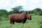
These thickets grow on ecca shales and the spikey, often impenetrable, tangle of various acacia and albizia species is known as Delagoa Thorn Thicket or Gomondwane Bush. These thickets conceal one of Kruger's rarest animals, the black rhino. Also known as the hook-lipped rhinoceros because of the shape of its jaw (which differs from the square jaw of the white rhino), the black rhino has been saved from extinction by conservation efforts in South Africa, which has more than 60% of the world's population of this species.The different jaws of the white and black rhino reflect their eating methods - the black rhino is adapted for browsing while the white rhino is a specialist grazer. White rhinos may also be seen along the H4-2 where the bush is less dense. The thornveld along the H4-2 opens up from time to time to reveal small localised pans and vleis which are excellent birding spots after heavy rains. Gomondwane Dam at the junction of the H5 is an artificially fed water hole that is a popular drinking spot for impala, zebra and wildebeest.The Selati Line

The ill-fated Selati railway line was an expensive folly in terms of human life and hard cash. Intended to link the goldfields of the north-eastern Transvaal with the railway line from Komatipoort to Delagoa Bay, its construction witnessed so many tragedies that each sleeper on the line was said to represent one human life.
Work began optimistically enough in 1892 but, two years later, a financial scandal around the funding of the line erupted, the contractors ran out of cash and their company was liquidated. The line was laid only as far as Sabie Bridge (Skukuza), a mere 80km from Komatipoort.
During this period, thousands of black and white labourers were employed, truckloads of liquor were consumed and tens of thousands of animals were shot. The line was idle for 15 years - used only by James Stevenson-Hamilton and his rangers who had a handpump-powered trolley which they used to get supplies from Komatipoort - before the project was resuscitated. In 1912, the line reached Tzaneen.
For many years the line was in use but the closure of the Selati goldfields cast doubt on its viability. When Kruger was opened to the public in the mid-1920's the line was used for tourist traffic. However, Park authorities decided that the railway line was at odds with nature conservation and decided to close it down.
In 1972 the line was used for the last time and was then lifted. The last engine to go through the Park is now a monument at Skukuza and one of the original carriages has been turned into the Selati restaurant at the camp.

Part of the H4-2 follows an 18th-century footpath that once linked Chief Magashula's kraal at Phabeni to the coastal port of Delagoa Bay. One of the first traders in the Kruger area, João Albasini, had a store on this route as did the notorious lowveld gangster, Sardelli the Greek. The thorn thickets recede as the H4-2 approaches Lower Sabie Rest Camp and the landscape opens up dramatically.
This is because the underlying geology shifts from shale to basalt, which is associated more with a grassland environment. The Lebombo becomes visible to the east over the reedbeds of the Sabie River - the main koppie one sees to the north-east is Muntshe (435m above sea level).
This more open landscape is one of the best places in the Park for seeing cheetah. They prey on impala and other smaller antelope that feed on the sweetveld plains.
Duke's Water Hole

Duke's Water Hole - along the S137 - is a recommended stop. It is named after the legendary Tom Duke, Lower Sabie's head ranger for 20 years, from 1903 to 1923. As a boy, Duke survived an attack on his eastern Cape farmhouse during the Frontier Wars.
He went on to become a decorated hero during WW1. Like many of the other old guard, he was a respected, reliable, yet hard-drinking ranger. Stevenson-Hamilton said there were many times, during his uphill battle to develop the Park, that Duke felt like the only friend he had: "I always feel well when he is here. .. [It is] a pleasure to talk to him when he is sober," he wrote. When Duke died in 1934, Stevenson-Hamilton mourned his passing, noting his resilience and ability to deal with problems, even if they had been self-imposed.
Duke's has water all year round and is a draw-card for a variety of animals, including lion, which may sometimes be seen at dawn, drinking at the long finger-like waterhole. There are often white rhino along the S137.
The Battle of Gomondwane
One of the first recorded battles between Europeans and Africans in southern Africa took place in the Kruger Park. Historian Tim Couzens writes in Battles of South Africa how a party of 31 Dutchmen set off from Fort Lagoa (Maputo) on 27 June 1725 in search of the rumoured goldfields of the interior. Led by Johannes Monna, and recorded by clerk Frans de Kuiper, the expedition included "a corporal, a drummer, an under-master, an overseer of the pack animals, 20 soldiers and five sailors. There were also eight interpreters and servants.
For the transport of the provisions there were 10 pack-animals; for dinner on the hoof there were eight head of cattle". The Dutch party found the going difficult. They were regarded with suspicion and hostility as they progressed through the chiefdoms of Mattolle, Semano and Coupane between the coast and present-day Komatipoort. The local inhabitants had a good hunch that white settlers meant trouble and deliberately tried to undermine the mission with contradictory stories about gold and treasure, exacting payment for this "information". The Dutch suspected they were being deliberately duped and prepared for the worst. Tensions came to a head on 12 July when the party was ambushed by Chief Dawano and his warriors near the present-day site of Gomondwane Water Hole, north of Crocodile Bridge.
The Dutch had superior fire-power with their flintlocks - which the Shangaan warriors called hongo songilo ("beautiful sticks") - and managed to repulse the first attack, killing six of their assailants. Even though they had lost most of their gunpowder in the Sabie River, the Dutch used their weapons to good effect during their orderly retreat, keeping hundreds of chanting warriors at bay.
There were several more skirmishes before they crossed the Komati River and retreated to the more tolerant atmosphere at the coast. They reported to the commanding officer at the fort at Lagoa that they had done their duty but that the expedition had ended in failure and that the famed goldfields of the interior remained as elusive as ever. Gomondwane is the name of one of Chief Dawano's descendants who lived in the Park until the early 20th century.
 Just a stone's throw from the Mozambican border and Maputo, Crocodile Bridge Camp is rich in local history and is the best half-way house yo...
 From Lower Sabie Camp you have the opportunity to watch the endless procession of animals coming to drink at the Sabie River. Visitors canno...