In 1998 South Africa passed a new National Water Act. This act was hailed internationally as an innovative approach to water management, as it took a holistic view of looking after South Africa's scarce water resources. The act uses the tool of Integrated Catchment Management to make sure all the users of a river system realise their place in the entire system, so that one user does not produce harmful effects on other users further downstream.
The country was divided into 19 Water Management Areas, each of which is based on major rivers and their tributaries. Each of these areas is expected to form a Catchment Management Agency, which will be made up of the stakeholders who use water from the river, such as government, farmers, miners and municipalities.
These people will provide a storehouse of local knowledge that should more effectively govern how the water in a system is used than external officials who do not live in the system. Each water management area is further subdivided into many smaller management areas, consisting of many Water Users' Associations, which are registered with the Department of Water Affairs and Forestry (DWAF).
19 Water Management Areas in South Africa
- Limpopo
- Luvubu and Letaba
- Crocodile West and Marico
- Olifants
- Inkomati
- Usuthu to Mhlatuze
- Thukela
- Upper Vaal
- Middle Vaal
- Lower Vaal
- Mvoti to Umzimkulu
- Mzimvubu to Keiskamma
- Upper Orange
- Lower Orange
- Fish to Tsitsikama
- Gouritz
- Olifants/Doring
- Breede
- Berg
Steelpoort Sub-catchment
The main land uses in this area are agriculture, mining and rural settlements. This sub-catchment may undergo radical changes in the near future. The Steelpoort River is the focus of an environmental impact assessment process for the construction of an 80m high dam on the farm De Hoop. This dam is intended to provide water to the booming mining industry in the area, especially platinum mines, as well as many of the poor local communities in the area.
It forms part of the Olifants River Water Resources Development Project (ORWRDP). The dam would be built so that it could meet the ecological needs of the Steelpoort River, but it would still reduce the water flow into the Olifants River, making it less likely that the ecological reserve would be met. This is expected to be the last large dam ever built in the Olifants River WMA.
Lower Olifants Sub-Catchment
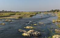
Water entering this catchment from the Middle Olifants area is often full of sediment and chocolate brown in colour. Water quality is only improved downstream by the good quality water entering the system from the Blyde and the Mohlapitse Rivers. It is in this area that water enters the Kruger National Park from the Phalaborwa barrage. The water released from the barrage is sometimes so laden with silt that the water kills fish in the KNP.
A tender process is in place to see if the effects of the silt can be mitigated in future. The Selati River also enters the Olifants River in this area. The Selati is now cleaner than before as DWAF has enforced licensing of the release of polluted water. This has forced Foskor into recycling most of its water within the mine. This has lowered the amount of water entering the Olifants but improved its quality.
Middle Olifants Sub-Catchment
This area contains the highest number of people in the various sub-catchments, most of whom live in rural settlements. There is a good deal of subsistence farming being practised. There is also commercial agriculture irrigated with water from the Loskop Dam. Increased mining activity in the area is being catered for with the raising of the Flag Boshielo (formerly Arabie) dam wall by five metres.
At the moment the mines are buying water rights from agricultural schemes in the area. When the dam wall is raised the water rights will go back to the agricultural schemes, which require some rehabilitation. The main problem in this area is caused by poor agricultural practises, which create a heavy sediment load in the river.
Overgrazing, planting of crops in wetlands, planting of crops on sloping land without contour ploughing, and other poor farming techniques result in extensive soil erosion and high runoff of rainwater. However, many of the people living in this area are extremely poor and subsistence farming provides them with food. The loss of wetlands in this area means that when rain falls the water is not slowly and continuously released into the Olifants, but runs off rapidly and is polluted with sediment.
Upper Olifants Sub-Catchment
The Upper Olifants sub-catchment is the most urbanised section of the catchment and is dominated by coal mining. Witbank and Middelburg fall into this region. It has some of the largest thermal power stations in the world. The water quality here is influenced by the coal mining activities.
However, a group called Coaltech 2020 has been doing considerable research into recycling and economically cleaning up polluted mine water, so as to comply with DWAF regulations on emitting polluted water into watercourses. The Wilge River has the least coal mining activities in this region and so improves the quality of the water in Loskop Dam. Water from Loskop Dam is used for irrigation.
Did you know?
Fundamental to the water act is the concept of the reserve of a river - a certain amount of water that will meet both basic human needs and provide enough water to protect the aquatic ecosystems of the water resource. The reserve refers to both the quantity and the quality of water in the river, and is determined through scientific study. The successful management of a catchment means that the reserve flows throughout the river's length all year round, despite the presence of dams and other water use.
 Six major rivers, stretch across the wilderness of Kruger National Park, the Crocodile River, the Limpopo River and the Olifants, Sabie, Let...