
For much of the 1970s, several researchers were involved in the very first comprehensive vegetation analysis undertaken over the entire area of the Kruger National Park (KNP). During this vegetation survey, led by Willem Gertenbach, aerial photographs of the park were used to locate some 3,000 different sample locations in the different vegetation types.

For each species found, their relative abundances would be marked down, and the amount of cover the tree crowns provided would also be recorded. For example, crown cover could vary from one tree with a huge canopy covering most of a plot, to numerous small trees all with small crowns covering a similar size area.
More Than 1,500 Kinds Of Plants In Kruger
Considering that the park is now known to have more than 200 different kinds of grasses, around 400 different kinds of trees and shrubs and well over 1,000 other sorts of plants, such as herbs, succulents, creepers and ferns, a keen eye for detail was necessary to carry out the field work.After several years of this fieldwork, Gertenbach was able to describe in the region of 300 plant communities in Kruger. Although this knowledge of which plants grew in association with which other species was valuable, it was not of much help to park management, who could hardly be expected to develop a different management protocol for each plant community.Gertenbach describes it as "using a magnifying glass to look at an elephant." Just as equally, previous classifications of the vegetation types in the park were too broad to help management, dividing the park into a mere handful of veld types. By the time all the vegetation mapping was complete, almost a decade had passed since Gertenbach had been hired, initially to review the condition of the veld near Satara.During this time surveys had also been carried out of the soils and geology in the park, and the annual aerial censuses of the animals showed which species occurred where. Looking at the vegetation information, Gertenbach was able to see that in some areas several plant communities were repeated over and over, as the vegetation changed up and down hill slopes.
These sequences of plant communities, together with the underlying soils and geology, and the associated browsers and grazers that fed on the plant communities, could then be lumped together in a unit of a suitable size for management purposes.
Identification Of 35 Landscape Types
The careful compilation of the various combinations of geology, soils, plants and animals into management units took some time, especially as computing power was seriously restricted in the early 1980s. All the data from the thousands of field sites had to be sent to a college where a sophisticated computer (in those days) could help analyse the data.Gertenbach's work culminated in 1983, in the publication of a paper simply entitled "Landscapes of the Kruger National Park" in the Sanparks scientific journal, Koedoe.The paper describes 35 different landscapes in the Kruger Park, with each landscape being home to particular plant communities and associated animals, or as defined by Gertenbach, "an area with a specific geomorphology, climate, soil vegetation pattern and associated fauna".
Management Implications
These landscapes have been simplified and used to create the visitor's ecozone map, which helps tourists know what to expect to see as they drive through the park. Using these landscapes, management can look at the results of routine vegetation surveys carried out by section rangers, and be satisfied that a survey carried out hundreds of kilometres away from another survey will be comparable if they lie in the same landscape.The landscapes also help provide a basis for management decisions such as placement of waterholes, location of rest camps, placement of fire breaks and a knowledge of which areas of the park contain rare species, are botanically sensitive or in need of more intensive monitoring. The descriptions of the various landscapes are also frequently used by scientists when starting their research.Adjoining Protected Areas
With an increasing amount of land coming under conservation next to Kruger in the form of the Limpopo National Park to the east and private nature reserves dropping their fences to the west, the landscapes also provide a basis for vegetation comparison across a wider area.This also gives insight into the effects different management can have on similar landscapes, as the three broadly divided protected areas all have different management regimes. The increase in computing power over the years and the advent of satellite imagery has helped speed up the classification of landscapes in these areas.
Private Nature Reserves
To the west of Kruger, Mike Peel from the Agricultural Research Council has hands-on knowledge of the vegetation in many of the private reserves adjoining and near Kruger from many years of ecological monitoring in the lowveld. Management of these areas is complex due to a wide variety of different land user objectives and areas that vary greatly in size.Combining the data collected by Peel and his colleagues John Peel, Andre Jacobs and Theresa McDonald and by analysising available satellite data, he has identified seven different plant communities in the private protected areas that fit into four of Gertenbach's Kruger landscapes. These are the Mixed Combretum -Terminalia sericea Woodland, Combretum collinum/Combretum zeyheri Woodland, Thickets of the Sabie and Crocodile Rivers and the Combretum/Colophospermum mopane woodland of the Timbavati area.
Limpopo National Park
East of Kruger in Mozambique, independent ecologist Marc Stalmans has studied the Limpopo National Park (LNP), part of the Greater Limpopo Transfrontier Park. He was commissioned to help map the vegetation so that a management plan for the park could be created after it was proclaimed in 2002. Also using satellite imagery and vegetation analysis from chosen field sites to identify plant communities, he was hampered in his work by the limited available time and the lack of access roads in the LNP.To get an idea of the vegetation growing in inaccessible areas, he made use of helicopter flights over the park to get to remote locations, where he could take digital photographs to help record more information. At the end of the study, 15 plant communities were found that were grouped into 10 of Gertenbach's landscapes.One of the most interesting discoveries in the LNP was that almost half the park is made up of sandveld, covering an area 30 times larger than all the sandveld areas in Kruger combined. This means that the LNP has much higher numbers of many species that are considered to be rare in South Africa and are afforded special protection here, such as Pterocarpus lucens (small-leaved bloodwood, kleinblaarkiaat).
Different Management Types
With the combination of Gertenbach's landscapes and the classification of the land east and west of Kruger, there are many opportunities for scientists to look at what happens in particular landscapes when they are managed differently. The smaller private reserves west of Kruger need to have more intensive management guidelines than Kruger because of their size, and they also have different priorities that they manage for.On the other hand, the Limpopo National Park has had little in the way of formal management for many years, and has indigenous people living in subsistence communities within the park. The thousands of tedious man-hours spent by people like Gertenbach, Peel and Stalmans identifying and cataloguing grasses, herbs and trees in the field provide a solid foundation not only for the creation of colourful tourist maps, but also provide the opportunity to build a comprehensive baseline to measure how man's actions and natural influences like global warming can affect the biodiversity of protected areas.By Melissa Wray
In the Great Limpopo Transfrontier Park
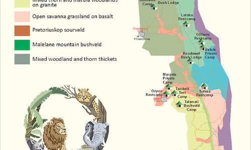 This ecology map of Kruger Park describes the location of the various camps in relation to the climate and vegetation. The vegetation determ...