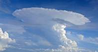
Pilots may soon be able to avoid rain and turbulence if a new method of analysing satellite data takes off. Developed by scientists at the University of Alabama at Huntsville, NASA and the University of Wisconsin, the system is about 65 percent accurate in giving a one-hour warning of heavy rains within a thunderstorm.
The new system takes visible and infrared images from two different satellite systems and merges them. This allows the model to get new cloud top temperature readings every 15 minutes.
This will show if the cloud is getting bigger or forming ice, which affects the amount of lightning in a storm. Turbulence which cannot be seen by either the human eye or Doppler radar can also be detected by the system. The model reveals the turbulence, which can form invisible waves similar to those on a beach, by showing bands of hot and cold radiation.
By knowing about heavy thunderstorms and powerful turbulence up to an hour in advance, pilots can take evasive action, improving safety, comfort and efficiency as well as saving money. The satellite data also covers most of the planet, giving information on areas not covered by other aviation weather prediction systems.
 For travellers wanting to skip the long road transfer and arrive in the bush in just over an hour, flying from Johannesburg’s OR Tambo Int...