
Almost half of the southern section of the Kruger National Park has been burnt, with the month of August seeing a large fire in the Pretoriuskop area. Currently, almost three-quarters of the land in the Pretoriuskop section of the park has been consumed by lightning-induced flames. Prior to August, only 17 percent of the land in this section had been burnt.
Much of the southern section of the park fell prey to fire in August, with the area of burnt land increasing least in Lower Sabie (by eight percent) and most in Pretoriuskop (56 percent increase). Stolznek, Skukuza, Malelane and Crocodile Bridge in the southern section of Kruger all experienced fires, as well as Satara in the central section and Mahlangeni in the northern region.
This time of year is considered to be the worst for hot, wild fires. High temperatures, low humidity and high berg winds produce ideal conditions to fan flames in the tinderdry grass. Until the first rains fall and the veld starts to green, section rangers in the park will be increasingly watchful for smoke plumes.
Around the entire park, about 20 percent of the surface area has been burnt, with many of the fires in the central, northern and far northern sections being planned burns started by section rangers earlier in the year. Every year, park management uses data gathered from over 520 vegetation monitoring sites to determine where and what percentage of the park should be burnt.
Only if the preceding years' rainfalls have produced grass coverage of over four tons per hectare are burns considered to be ecologically necessary in Kruger. When the year's fire regime has been worked out, section rangers set fires at the beginning of winter in chosen locations to break up the veld into a patchmosaic.
This scattering of burnt and unburnt sections acts a means of preventing unplanned runaway veld fires that may occur later in the season. Burning early in the year also makes for a cooler fire, which is less likely to turn saplings into stunted, multi-stem trees. At this time of year, lightning storms and illegal immigrants travelling through the park are major cause of fires.
However, many of the August fires in the central and northern section of the park were set by rangers, while the Pretoriuskop fire and others in the southern section were started by lightning. Section rangers provide information about the extent of burning in an area and source of fire. Satellite images are also used to map the location and size of fires.
MODIS satellite images are downloaded twice a day, and subjected to analysis that reveals burnt patches. If a fire is noted on the satellite image that a ranger has not spotted, the ranger goes out to the location and 'ground truths' the digital information. This is then compiled into a database and digital maps are kept in the fire ecology section of scientific services.
Statistics kept for this year show that at the end of August, less than one percent of the far north of the park had been burnt. Approximately 10 percent of the northern region, almost 16 percent of the central region, and 49.3 percent of the southern region had been blackened by flames.
Fire ecology programme manager Navashni Govender says that the amount of rain falling in the previous two years has the greatest effect on how much of the park burns in a given year.
By Melissa Wray
In Kruger National Park
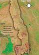
 The botanically rich, high-rainfall mountainveld of the south-west provides habitat niches for some of Kruger's rarest antelope. This is the...