The Greater Mapungubwe Heritage Route celebrates the rich history of the northern part of the Limpopo Province of South Africa over the last 1 000 years.
Brief Background
The Greater Mapungubwe Heritage Route links numerous cultural and natural heritage sites through a circular route centred around key sites such as the Mapungubwe World Heritage Site, the Thulamela Archaeological Site and the cluster of heritage sites around the sacred Lake Fundudzi and royal Dzata Museum.
The Greater Mapungubwe Heritage Route starts at Louis Trichardt (Makhado) and dates back about 1 000 years.
From Louis Trichardt it follows a circular route to the west along the Soutpansberg until Vivo. It ends amongst the largest colony of Cape vultures in South Africa at the Blouberg Nature Reserve.
From Blouberg the route goes north to the Greater Mapungubwe Transfrontier Park and World Heritage Site.
From Mapungubwe it goes east via Musina to the Greater Nwanedi Wildlife Reserve with its two beautiful dams and the Sagole Big Tree - the biggest boabab in South Africa and one of the biggest trees in the world.
The Makuya Nature Reserve is the next stop and is characterised by stunning views over the Kruger National Park (KNP) at places such as World View, the Luvhuvhu Gorge and at the Singo Safari Lodge.
The Route then moves into the KNP to the Thulamela Archaeological Site - one of the primary heritage sites of South Africa, and the link between Great Zimbabwe and the modern Vha Venda nation.
Crooks Corner where South Africa, Zimbabwe and Botswana meet at the confluence of the Pafuri and Limpopo rivers is the centre for the Great Limpopo Transfrontier Park and has a fascinating history.
From Crooks Corner the route turns southwest towards the Punda Maria gate of the KNP to enter the heartland of the Land of Legend in the Nzhelele River Valley.
The heart of the Land of Legend is formed by a cluster of heritage sites such as:
- The mysterious and sacred Lake Fundudzi
- Dzata - the royal history of the Vha Venda
- The Holy Forest
- The Sacred Tswime Mountain
- Tshivhase stone terraces
The next stop is Valdezia - the first Shangaan settlement in South Africa; then to the historic mission hospital of Elim, start of the Ribollah artist route and then to the Skirmishes Route, highlighting a number of very significant incidents during the Anglo-Boer War.
1. The Mapungubwe World Heritage Site
Mapungubwe was declared as national monument on 18 August 1984. Mapungubwe as an archaeological site received prominence in the 1930's with the discovery of golden ornaments and artefacts. Mapungubwe is situated approximately 2,5 km south-east of the confluence of the Shashi- and Limpopo Rivers, on the farm Greefswald. Mapungubwe consists of Bushveld sandstone and is approximately 300 meters long. It has a flatcrown vertical wreathe of some 30 meters high.
The hill itself has an elongated shape, with 80 metre high cliffs surrounding the greater part of its periphery. Access to the top of Mapungubwe is not easy, and there are only seven known ascents, of which only one is reasonably safe to use in both directions.
Gold was found in a graveyard on top of the hill, where 33 burials were discovered - each of which had a variety of golden beads, bangles and other golden decorations entombed with it. No burials with gold had been discovered elsewhere, therefore it has been accpted that an aristocracy was living on top of Mapungubwe Hill. Further archaeological evidence confirms this, and changes that took place socially, politically and culturally started the processes that led to the beginning of the system of divine kingship evident at Great Zimbabwe.
Settlement structure at Mapungubwe places the hill at the centre, with the town spread out around it. There was clearly a demarcated main entrance for visitors to enter, which led them past houses to the foot of the hill where the court was situated between large upright boulders. Excavations have uncovered steps, terrace walls and directional walls, which demarcated this area from the rest of the town. It is generally accepted that the main way up to the top of the hill was through the court, and that there were several guards whose duty it was to limit access to the top of the hill, thus ensuring that the king was not disturbed. We can be certain that the ruler lived up here, as it is not accepted in such a manner that commoners would look down upon his residence. He also had to reside close to the court. Evidence of the existence of the leader is non-existent and of other early villages, this is indicative of the fact that the ruler now has other priorities to which he must attend and can no longer be bothered by ordinary problems. Unless his advisors and councillors could not solve the problems, people wishing to see him would first have to get past all these officials before being granted and audience. Numerous archaeological sites of these old villages are still to be seen along the Soutpansberg, extending deep into the heart of present-day Venda. At about 1250 AD, it appears as if the town of Mapungubwe was abandoned for reasons still unknown.
The importance of Mapungubwe lies in the first manifestation in Southern Africa of a class-based society as opposed to a rank-based one prevalent earlier, and this led ultimately to the rise of the Great Zimbabwe Empire.
2. Thulamela Archaeological Site
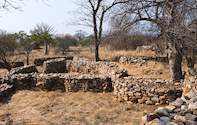
This early Iron Age site, dating 1250 - 1670, is the oldest reconstructed structure in Africa and is the best-preserved post-Zimbabwe period site of its kind. The old stone ruins at Thulamela are thought to be of the same culture and civilisation as the Munomutapa in Zimbabwe. This site completes the last phase of the well-known Zimbabwean culture period and is of major importance in the reconstruction of the history of Southern Africa. Thulamela consists of re-built stonewalls of a village community that existed in or about 1450 AD. It is located on a hill west of the Phafuri picnic-site in the KNP and overlooks the Luvuvhu River and the Limpopo River valley.
The Thulamela people left Zimbabwe after the collapse of Great Zimbabwe and headed south across the Limpopo River establishing a number of chieftaincies of roughly equal status along the Limpopo Valley. Unlike Mapungubwe, which is too long ago, Thulamela can be directly linked to the Venda of today. Excavations at the site revealed the grave of a king. Once archaeological information had been collected, his bones were respectfully reburied during a ceremony that showed the Makahane people acknowledging their ancestors.
The walls of Thulamela have been largely re-built and, to date, represents the oldest restored buildings in South Africa. Excavations have revealed gold bracelets and beads, ivory amulets, clay pots from the Khami era, glass and shell beads, harpoons, spearheads and ceramic spindle whorls. Of particular importance was the discovery of the grave of a lady of high estate. She was found lying on her side in the 'Losha' position, showing respect, with her hands on the left side of her face, and with a gold bracelet around her arm. She was named 'Queen Losha' by the excavation team.
The layout of the capital reflects the pattern of Ritual Seclusion of the Sacred Leader started at Mapungubwe, and carried on through Great Zimbabwe. There is a stillness and an aura of mystery that surrounds these ancient walls, surrounded by some huge old baobab trees.
Other sites within the Thulamela Node include the Limpopo river basin, an area that, most probably, boasts the longest continuous human occupation in the southern sub-continent stretching over more than 1.5 million years. Wherever one walks on the Limpopo floodplains, one treads on Stone Age tools. The tools also occur along most of the streambeds and extend over a distance of more than 150 kms into Mozambique. Large concentrations of Early Stone Age tools occur in the Phafuri area and this area is also rich in Middle and Later Stone Age sites.
3. Lake Funduduzi
Lake Fundudzi is located in the Soutpansberg in the upper catchment of the Mutale River inside Thate Vhondo forest. Measuring about five kilometers by three kilometers when full, this lake is unique in Africa as it was created by an ancient landslide blocking the course of the Mutale River. The lake and its resident crocodiles as well as the nearby forest of Thathe Vondo, are regarded as sacred by the Vhatatsindi, the People of the Pool, who are part of the Venda people.
According to Venda legend, the lake was created when a passing leper was refused food and shelter. He cursed the kraal which disappeared below the waters of the newly formed lake and the Venda claim that in the early morning it is possible to hear the sound of drums and the cries and bellowing of the drowned people and cattle.
Legend also believes that Lake Fundudzi is protected by a python god living in the mountain. The Venda pay homage to this god by annually performing a puberty dance, characterised by the sinuous swaying and writhing of a conga line, in which adolescent girls of the tribe take part. The fullness of the lake and its colour are said to reflect the temper of the ancestors, and the possibility of rain. Plans are underway to declare it a national Heritage site.
4. Dzata Heritage Site. (Vhembe District)
Situated between Louis Trichardt and Thohoyandou. The remains of the old capital of the chiefs of the Venda people dating back to 1400 AD.
Location
Dzata is located in the eastern section of the Soutpansberg mountain range in Vhembe District, in the north-eastern part of Limpopo Province. It lies adjacent to the Nzhelele Valley, some 40 kilometres to the west of Thohoyandou near the offices of the Mphephu Tribal Authority. The southern section of the reserve lies on the southern foothill of the mountain, immediately north of the village of Ha-Mandiwana. It stretches up and over the mountain into the raised valley lying to the west of Tshiendeulu Village. The western boundary is at the peak, given as Ha-Mandiwana, while the eastern boundary runs between the mountains, indicated as Tshamilora and Gumbila.
Significance
Among the original places where the first Dzata settlers came from was Tshiendeulu. Khosi Netshiendeulu was one of the earlier leaders. The son of chief Dimbanyika, who was called Dyambeu, built the chief's village at Nzhelele. After his father, Dimbanyika, passed away at Tshiendeulu, he moved to Nzhelele where he built his settlement. These people moved from Tshiendeulu to Nhzelele in about 1723. They settled and lived at Dzata until about 1760. The groups that were around that area at the time, like all the Bantu-speaking communities, had migrated from northern and central parts of Africa. The communities, which settled in the Dzata and surrounding areas, are the ancestors of the present Venda people.
One of the most revered leaders, who was a descendent from Dzata, was Khosi Makhado. Khosi Makhado was regarded by the colonial forces as "the troublesome Venda chief" because of his power and their inability to defeat him. Makhado was powerful as he settled in the mountainous stronghold which made it difficult, if not impossible, for his enemies to dislodge him. His position was also strengthened by a string of alliances he forged with other strong Black chiefs like Sekhukhune and Malebogo.
After establishing the ZAR government following the 1852 Sand River Convention, the Boers set themselves a task to subjugate Black chiefdoms. This task proved difficult when they arrived in the north, coming face to face with Makhado.
The Voortrekkers established their settlement next to the Venda chiefdom, naming it Schoemansdal, and this set out a scene for direct confrontation. By 1867, the Boers had assembled a formidable force under the command of Paul Kruger. A fierce war ensued in which the Boers eventually retreated, abandoning Schoemansdal. The Boers retreated to Marabastad in the vicinity of the present-day Polokwane. To the Venda, this was a significant victory against the Boers.
According to available sources, Makhado was born between 1830 and 1840, and was the son of Khosi Mphephu Ramabulana and his wife Lemani. He worked as a labourer on White owned farms and also, importantly, as a tracker for elephant hunters. He was such a good assistant and gun carrier that the hunters taught him to use a gun and he became a good shot. He also earned their trust to such extent that they gave him and his men guns to hunt on their own. Many of these guns were never returned, and were later used against their attacking enemies, particularly the Boers.
When Ramabulana died in 1864, Makhado's brother, Davhana, was supposed to take over the reigns. However, Makhado succeeded to take over power where upon his brother fled. During his reign, troubles with the ZAR government surfaced when he refused census among his people, while he also refused to pay ZAR taxes. The Boers, regarded this as defiance of their authority and they waged war against Makhado, which led to their retreat in 1867.
Khosi Makhado died on 11 September 1895, allegedly from poisoning which happened during a brandy-drinking session at John Cooksly's shop. After the death of Makhado, the Boers were able to return to the north four years later, to establish another small town not far from the abandoned Schoemansdal, naming it Louis Trichardt, after another pioneering Voortrekker leader.
GPS CO-ORDINATES
- North west corner 22º 50' 45" S; 30º 07' 15" E
- North east corner 22º 50' 15" S; 30º 10' 08" E
- South east corner 22º 51' 30" S; 30º 10' 45" E
- South west corner 22º 52' 07" S; 30º 08' 23" E
5. Tshiendeulu (Nzhelele)
Archaeological site dated back to the Iron Age period. Tshiendeulu consists of old ruins, which was the original settlement of the Shi-Venda Royalty before the migration to Dzata. It is located on the plateau overlooking Dzata.
6. Malebogo-Boer War Battlefield. (Capricorn District)
Location
This vast site is about 60km from the small town of Senwabarwana. The site covers a huge area because of the nature of the war between the Bahananwa and the Boers, in which the Boers established tents all over the area in preparation of the assault. The vast site covers the farms Leipzig 264, Buffelshoek 261, Beauly 280, The Grange 257, Wiltstein 256 and Veredig.
Significance
Kgoši Malebogo was involved in a struggle against the White encroachment on his land towards the end of the 19th century. The Boers, who had established the republic, the ZAR in the north, were determined to subjugate all Black chiefdoms. The then Commissioner for Native Affairs in Zoutpansberg (Nothern) Division, Swart Barend Voster, who was based in Kalkbank, set the stage for the war by insisting that the Bahananwa should meet the ZAR's demands. The then ZAR president, Paul Kruger, instructed Commandant-General Piet Joubert, to lead the Boer forces to attack the Bahananwa.
Piet Joubert assembled a strong force of the commandos from Rustenburg, Marico, Zoutpansberg as well as the allies of Black chiefdoms such as the Matebele of Langa and the Bakone of Matlala and attacked the Bahanawa. Malebogo put up a very strong resistance, but with such strong force and heavy weaponry against him, he finally surrendered on 31 July 1894. Kgoši Malebogo was taken to Pretoria as prisoner. During his imprisonment, the Bahananwa was ruled by his mother Mmaseketa, Maemeletša and Sephuti. Kgoši Malebogo was released in 1900 during the Anglo-Boer War and he continued to rule his people until his death in 1939.
Kgoši Malebogo's remarkable contribution to the history of South Africa is perhaps his resistance against colonial forces. After the Boers regained the independence of the ZAR (Transvaal) from the British in 1881, they intended to subjugate all the Black communities in the Transvaal, including the Bahananwa. The refusal of the Bahananwa to submit under the ZAR government and to pay taxes led to the Bahananwa-Boer War of 1894.
The history of the Bahananwa forms an integral part of our national heritage and should be identified, developed and preserved for future generations. In addition to the rich history of the Bahananwa, the adjacent Blouberg areas are richly endowed with cultural and natural resources. The rock art paintings, which are found in the Makgabeng and Blouberg Mountains, indicate that the Khoisan people were the earliest inhabitants of the area.
7. Valdezia Mission Station (Valdezia)
Valdezia is the first Shangaan settlement in South Africa, it is located 25km east of Louis Trichardt and 10km north east of Elim Hospital. Shangaans occupied and colonised the area in the early 1800s. Shangaans are Nguni people, who came from Nongoma in Northern KwaZulu Natal. Their original leader was King Zwide of the Nxumalo clan in northern KwaZulu Natal.
When King Zwide went into war with the Zulus, led by Shaka Zulu, he was defeated. After the defeat, the Nxumalo clan disintegrated and the once powerful military commander of the Zwide forces, Soshangane refused to submit to the authority of the Zulu. Fearing Shaka's brutal leadership, Soshangane left Nongoma with his followers to establish a new Kingdom elsewhere.
He named the new Kingdom Gazankulu in honour of one of the Zwide Kings, King Gaza, his grandfather. Life was not peaceful in the new Kingdom and Gazankulu came under attack by the Portuguese settlers in Lourenco Marques, now Maputo. This led to the second migration of the descendents of Soshangane and the Shangaans moved into the Transvaal. Valdezia became their first settlement in the Transvaal.
While in Valdezia, the Shangaans were joined by a Portuguese settler named Joao Albasini, though his full names were Dos Santos Joao Albasini. Albasini spoke fluent Tsonga/Shangaan and the Shangaans felt at home with Dos Santos Joa Albasini.
Dos Santos Joao Albasini was later to become their tribal leader and up until today, Shangaans gather annually at Albasini Dam to pay their last respect to the man they considered their leader. The Shangaan Settlement at Valdezia was not all peaceful and when the Boers arrived competition for land begin. Whites established farms next to Valdezia, The Farm Klipfontein where Valdezia currently is, co-existed peacefully with a Shangaan settlement nearby.
In 1875, two Swiss theology students, Ernst Creux and Henri Bertroud purchased the farm Klipfontein from Mr. Scot J. Watt in order to build a Mission station and settle Shangaans there. They named the station Valdezia, in honour of their native homeland in Switzerland, Vaud. Alexis Thomas, a missionary and artisan, cared for the entire Mission Station area included Old Valdezia School, Elim Mission Church, Elim Hospital, Lemana College, Elim Mill, the dam and other historical structures. This is the first town where the first Shangaan were converted to Christianity, also in 1875.
Situated in the Soutpansberg District to the south-east of Louis Trichardt is Valdezia Mission Station, an establishment that has come to represent a portion of South Africa's Heritage. Valdezia Mission Station in Limpopo has done much to benefit the local population and uplift the community, while providing insight into the past.
Large numbers of Vatsonga people began moving into the area from the country of Mozambique. This great migration is chiefly attributed to Mfecane-Difaqane upheavals directed from Zululand. Additionally there was an ongoing power struggle amongst Vatsonga chief Soshangane's own sons. The Swiss Mission converted several of the Vatsonga people to Christianity. Shisozwele and his family were the first to convert. Shisowele's daughter, Shiambane, became the grandmother of the Marivate family, a very well-known family name. As the missionaries at the station carried on the teaching, the congregation increased and so a church was built. Soon the Mission Station was a developmental hub in the area. The mission house was constructed in 1884 and the church two years later in 1886.
It was in 1888 that Valdezia primary school was set-up. Several well-recognized members of South African society were taught at the school, such as T. Mandlate, minister at a Maputo church, D. Marivate, became a school teacher, composer and poet, C. Marivate, now a parliamentarian, and Dr Manghezi, today at the Development Bank of Southern Africa. The Swiss missionaries certainly left their mark on an area that previously had no hospitals, churches or education establishments. In 1999 Valdezia Mission Station was declared a national monument.
8. Buysdorp (Mara)
Buysdorp is situated on the R522 road between Louis Trichardt and Vivo. This settlement is based on the descendants of the patriarch Coenraad du Buys. In 1888 President Paul Kruger allotted this area to the Buys community. It includes the farm Kalkoven, as well as surrounding farms up to 1000 hectares and was a reward for siding with the Voortrekkers during conflicts between the Schoemansdal people and the Venda leadership of the time. This territory, known as Mara, is still occupied by the Buys community today.
In the 1790s De Buys was an outlaw with a price on his head, wanted by the British for his illegal activities along the Great Fish River. Archival documents depict him as a wild creature, half man, half lion, given to helping himself to other men's wives and cattle. Indeed, several historians hold that his cattle raids and provocative entanglements with Xhosa women were the root cause of the Second Frontier War in 1793.
Within a year or two, however, De Buys had crossed the river and allied himself to his former enemies, becoming an important adviser to paramount chief Ngqika and the lover (some say husband) of his mother, Yese. In this period, De Buys also made a foray into present-day KwaZulu-Natal, where he was rumoured to have established a second alliance (also cemented by marriage) with Mzilikazi, founder of the Ndebele nation. These developments caused alarm in distant Cape Town, where De Buys was viewed as a dangerous trouble maker, entirely capable of instigating 'savage Caffres' to attack the colony.
In 1803, Governor Janssens offered De Buys and some other renegades a pardon, and De Buys returned to the Cape Colony, which is where Lichtenstein met him. He was about 45 at the time, and the patriarch of a growing band of half-caste sons and daughters. A century earlier such families were commonplace among Cape trekboers, but racial attitudes were hardening and the Buysvolk, as they were known, were not welcome in the Langkloof - especially after Coenraad testified against a white woman accused of mistreating a slave. By 1813 or thereabouts, De Buys had had enough. He loaded his wagons with gunpowder and trekked off into the unknown again.
9. Schoemansdal Museum (Makhado)
This archaeological site is situated approximately 17 km west of Makhado. Voortrekker leaders Louis Trichardt and Andries Potgieter established the settlement originally known as Zoutpansberg or Oudedorp. In 1855 the settlement was renamed in honour of Stefanus Schoeman, successor of General Andries Potgieter, to become Schoemansdal, which was rebuilt opposite and to the north of the original settlement. Schoemansdal was a progressive town which flourished mainly due to trading in products from the hunt such as ivory, yellow wood skins and other hunting products. The reconstruction of the first settlement, which now serves as a reconstructed open-air museum, illustrates the lifestyle of the Voortrekers between 1848 and 1852. Domestic animals such as Nguni cattle, Pedi sheep, goats and pigs can be seen. The grave of Voortrekker leader Andries Hendrik Potgieter can be seen in the cemetery. A large variety of Voortrekker architecture and lifestyle is interpreted at the museum.
In the early 1800's, Louis Trichardt was in the vicinity of the Soutpansberg and made contact with the Portuguese at Lourenco Marques. In 1837 the district governor of Lourenco Marques send two Askari's, accompanied by Gabriel Buys and some Shangaans to Louis Trichardt in the Soutpansberg to show Trichardt the route to Lourenco Marques. To mark the place where Louis Trichardt met the two Askari's, a bronze plate and beacon were put in place. The Louis Trichardt company would later succumb to malaria on this route.
10. Lemana Collegel (Elim)
The college is situated near Elim hospital. It was established in 1908 as one of the oldest institutions of higher learning in the area, which also produced prominent leaders.
Two theological students, Ernest Creux and Paul Berthold, offered their services as foreign missionaries "whether under the tropics or on the northern ice" to the Synod of the Free Church of Canton Vaud when it met in Lausanne in 1869.
They were sent to Morija in what was then called Basutoland. In 1875 they moved with five ox-wagons to what is today the Limpopo Province, establishing their first missions at Valdezia and Elim. This was the beginning of the work of what became known as the Swiss Mission Church in the area. It later became the Tsonga Presbyterian Church and is now known as the Evangelical Presbyterian Church.
Thomas Burgers, the president of the Zuid-Afrikaansche Republiek, was opposed to the presence of the Swiss missionaries and ordered their arrest and incarceration in Marabastad, but they were later allowed to pursue their work in the area. They bought a farm at Rossbach where they started a school with seven children, and named it Lemana, adapted from the name Lac Léman, a lake in Switzerland. The remains of the original Rossbach classrooms, scheduled for restoration by the provincial government as memorial to the work of the missionaries, are presently overgrown by vegetation and in a state of near-collapse.
In 1879 the mission opened the Elim Hospital, which still serves the people of the area. The school continued to grow and a teacher training institute was founded in 1906 which offered a broad curriculum.
The alumni of the school include leaders from neighbouring countries as well as residents of Limpopo and other parts of the country. They include Dr Eduardo Mondlane, Professor HWE Ntsan'wisi, Professor GM Nkondo and Judge GSS Maluleke.
11. Elim Hospital (Elim)
Elim hospital owes its existence to the Swiss missionaries. The original Swiss mission station was located in Valdezia, just 10 km north east of Elim.
Elim Hospital was the first hospital north of Pretoria. It was famous for its eye-care institute and many people travelled to Elim Hospital for medical attention. It has more emotional connection in the psychology of Shangaans than any other towns in the former Gazankulu territory. The first Shangaan Christians were converted at Elim and Valdezia respectively, and the first primary school, located in Valdezia was established in 1885. The hospital had electricity before Louis Trichardt (Makhado) town.
Elim has played a very important role in the literacy of early Shangaan intellectuals. The first Shangaan to write a novel and publish it in 1936 - Dr DC Marivate - was educated at Elim and Valdezia respectively. During the apartheid era, the white government attempted several times to remove Shangaans from Elim and Valdezia, without success, thanks to the Church of Switzerland. The farm Watervaal at Elim and the farm Klipfontein in Valdezia were purchased in 1875 by two Swiss theology students, and when the apartheid government tried to evict Shangaan in these settlements, the Church in Switzerland objected. Even today, the Church of Switzerland hold considerable power in both Elim and Valdezia.
There is a Museum within the hospital yard that is under renovation so that visitors can get an historical understanding of the hospital. This includes the history of the Swiss Missionaries, Anglo-Boer War and the local Chief, Njhaka-Njhaka, who leased the land to these Missionaries for 100 years. The Missionaries brought religion to the people of Njhaka-Njhaka and churches and schools were built for the community.
Today the graves of the missionaries, Anglo-boer Commandos and Second World War veterans are found within the vicinity of the hospital and the surrounding areas.
12. Happy Rest (Louis Trichardt)
Happy Rest as an early Iron Age site dating back to about 300 - 600 AD, and is situated 18 km west of Louis Trichardt on the Vivo road within a reserve, which is operated by Schoemansdal Environmental Education centre. The name derives from a culture of the Soutpansberg area that lived there at the time. Also found on the reserve are cycads, which needs desperate actions to protect them. The cycads are the same as those found at Modjadji.
13. Fort Hendrina (Louis Trichardt)
Collapsible steel Fort used during 1887 as protection for 25 artillerymen and later 100 mounted police is found in the centre of Lousi Trichardt. Apparently every time the fort was moved to a different place the name also changed. Fort Hendrina is therefore also known as Fort Edward. Fort Hendrina was named after the commander, commandant-general Piet Joubert's wife, Hendrina Joubert. The fort is situated in the town's Erasmus Street, next to the library.
14. Machemma Ruins, Solvent (Waterpoort)
This is an archaeological site, situated some 20km north west of the Waterpoort station, on a private farm off the Mopane road. These old ruins are believed to have belonged to the Thsi-Venda people, and show unmistakable affinity with the Great Zimbabwean ruins.
15. Stonehege on the Farm Bergvliet: (Louis Trichardt)
This is an old private residence situated in Makhado with the interior and building style dating back to the 18th century. It was previously declared a national monument and is situated in Snyman Street, Louis Trichardt.
16. Fossilised Footprints: Pontdrift (Pondrift border post)
This natural site was discovered in 1969, in the Holkrans sand stone, on the farm Pontdrift. The footprints dates back some 180+ million years or 180-million years. The prints were presumably made by three kinds of reptiles - Massospondylus, Tetrasauropus and Syntarsus. Very important of the site is that the prints are all pointing in the same direction at a decline of 27degrees.
17. Verdun Ruins
These ruins are situated six kilometres west of Mopani station on the farm Verdun between Musina and Louis Trichardt. These Venda ruins comprise of strong walls, which attracts the attention, of the Khotla or council-chamber, a typical chair for the chief. Behind the chair on the opposite side of the walls, is a short piece of wall with check patterns. These ruins are like the Machemma- and Dzata ruins and form an important connection in the pre-history of South Africa. This is of great value to the archaeologist and the ethnologist. These ruins can be associated with the movement of the Shona people southwards from Zimbabwe around 1500 AD.
OTHER IMPORTANT PROVINCIAL HERITAGE SITES WHICH WILL EVENTUALLY FORM PART OF THE ROUTE
18. Tjate Heritage Site (Sekhukhune District)
Location
This valley lies east of the Leolo Mountain and west of Tjate and Modimolle hills on the farms Dsjate 249 KT and Hackney 116 KT and south of the road from Mosego to Swale. The events during the Sekhukhune War cover a large portion of what is today known as Sekhukhuneland, but also links up with Burgersfort, Steelpoort and eventually with Mapochs' caves at Roossenekal and Botshabelo near Middelburg.
Significance
Kgoši Sekhukhune's long and bitter struggle against the Boers between 1876 and 1878, distinguished him to be one of the Black leaders of the same class as Shaka, Moshweshwe and many others.
The Bapedi originated from the Bahurutse branch of the Bakgatla in the present day Botswana, but they broke away and eventually settled in the eastern Transvaal around the Tubatse (Steelpoort) River and Leolo Mountains. In their new settlement, the Bapedi prominent leaders included Thobele, Thulare, Sekwati, and Sekhukhune.
The first missionary to visit Sekwati was a Lutheran of the Berlin Missionary Society, Alexander Merensky, in 1860. Merensky was later followed by other missionaries, Grutzner, Nachtigal and Endemann. The first mission station to be built was Gerlarchschoop and later Kgalatlou.
After Sekwati's death, a succession dispute ensued between his sons, Mampuru and Sekhukhune. Sekhukhune forcefully took over the crown whereupon Mampuru fled. The relationship between the missionaries and Sekhukhune began to deteriorate until the missionaries were ousted together with the chief's half-brother, Johannes Dinkwanyane, as well as many Christian converts. They settled at Botšhabelo (a place of refuge).
GPS CO-ORDINATES
- S 24° 31' 41.5"; E 29° 59' 26"
- S 24° 27' 53"; E 29° 59' 30.0"
- S 24° 27' 10"; E 30° 01' 12.5"
- S 24° 27' 41"; E 30° 02' 45"
- S 24° 30' 06"; E 30° 02' 46"
- S 24° 31' 27.5"; E 30° 02' 03
19. Soutini-Baleni Heritage Site (Mopani District)
Location
Soutini Baleni is situated 25 km further east of Nkomo-Goxani village near Mahumani vile on the southern bank of Klein Letaba River under the Mahumani Traditional Authority in Greater Giyani Municipality, Mopani District Municipality, about 35km on the eastern side of Kruger National Park.
Significance
Baleni-Soutini hot mineral spring (geo-thermal spring) is a unique natural feature in the otherwise arid Mopane veld wilderness, south east of Giyani, in Mopani District. It has been declared as a Natural Heritage Site (1999), because of its unique ecology. It is a hot spring of which the water has got mineral contents. A species of fish, the stunted population of Mozambique (Oreochromis mossambicus) lives in the fountain. The surrounding swamp is covered mostly by bulrushes and reeds.
Indigenous people have made salt at this fountain for the past 2000 years according to archaeological excavations. Stone tools also tell us that stone age people have been active at Baleni. There are three similar fountains in Mopani District Municipality, but all three have been destroyed by developmental activities. Baleni-Soutini is thus the only preserved salt production site, where indigenous people harvested salt according to indigenous technologies, practices and customs. Every winter local traditional women still produce salt at Baleni. Traditional customs, which accompany the salt making process, include interaction with the ancestral world through ritual and appeasement offerings at the sacred dry leadwood tree (the shrine). The natural fountain is significant to a broader indigenous community, because of its mythical character. It is referred to as Mukhulu.
The cultural landscape at Baleni includes ancient salt mounds, which date back to 250AD and which cover an area of 1.5 to two kilometers in radius from the fountain eye. The modern salt production site and the shrine, are also part of the cultural landscape. Oral history abounds and because of all the myths, legends and other stories that are well known to all the people in surrounding communities and regularly told to visitors, the place and the fountain is a sacred site.
Besides being a sacred site, it is especially a gendered site, because salt making is an activity that only the women practice. All the information, the indigenous technology and the oral traditions are transferred from one generation to the next. Of the many indigenous people mentioned in the prayers, who made salt at Baleni and who acknowledged the sacredness of the fountain, the following are mentioned in the oral tradition: VaKaranga, BaNyai, Balemba, VaVenda, BoLobedu, VaTsonga.
Traditional ecological knowledge abounds amongst the elders, specifically the traditional women, who live in close interaction with their natural environment, because they are dependant on it.
GPS CO-ORDINATES
S 23º-25'07.50,
E 30º-54'54.36
20. Makapan Valley World Heritage Site
The Makapan Valley World Heritage Site is situated on the farm "Makapansgat" some 19-km east north east of Mokopane in Limpopo. The Makapan Valley is unique, in that one can find, preserved in its many caves, in the form of sediments, fossils and archaeological remains, a record of human occupation and resource exploitation extending from australopithecine (ape-man) period about 3.32 million years before present through to present.
This evidence forms the foundation of the South African prehistoric sequence. Nowhere else within the confines of a single valley can such an extended and complete record of hominid activity be observed. The most important sites in the valley are as follows:
The Makapansgat Lime works and adjacent "Cave of the Horse's Mandible"
This is the oldest of the sites, spanning the time range of about 3.3.2 BP to about 1,6 BP. This site has yielded hundreds of thousands of fossil bones amongst which were found the remains of the gracile (lightly-built, smaller) australopithecine (Australopithecus africanus)
The Cave of hearths and adjacent "hyaena Cave"
Cave of Hearths preserves the stone tools and other debris left by early man who first occupied the site at around 250 000 BP. The overlying beds preserve an intermittent but extremely long record of human occupation, from +- 100 000 - 50 000 BP and again from 10 000 - 5 000 BP, and from iron age times to the present century. It appears that between 200 000 BP and 100 000 BP the COH remained unoccupied.
Fossils from the adjacent "Hyaena Cave " where the sediment infill is of greater age, suggest affinities with the Limeworks via occurrence of the remains of similar primitive hyaenas at both sites.
The Historic Cave of Makapansgat
The Historic Cave lies immediately adjacent to the COH and preserves Iron Age and Mfecane relics, but is most famous as the scene of a clash between a Boer Commando and local Langa and Ndebele people. Chief Makapan (Mokopane), together with a large number of his people and their livestock were besieged in the cave for nearly a month between 25 October and 18 November 1854 by Andries Potgieter.
The Rainbow Cave
This lies immediately below the eastern chamber of the Historic Cave and contains the remains of several hearth, distinguished as different coloured ash and sediment horizons and hence the name of this little "cave". The Rainbow Cave in all probability represents the lower part of the infill of the eastern chamber of the Historic Cave. The exposed sediments have yielded Middle Stone Age artefacts of the Polokwane culture, in the age range +- 100 000 - 50 000 BP.
The COH and Hyaena Cave, Historic Cave and Rainbow Cave together from part of a single interconnected large cavern complex, different portions of which were open to the surface and available for occupation at different times.
Peppercorn's Cave
The cave contains Iron Age and recent relics, and an underground lake, which Mr Peppercorn utilizes as a source of water. It is also home to a large colony of migratory long-fingered bats. (Miniopteris schreibersii)
Ficus Cave and the Ficus Iron Age Site
The cave contains Iron Age and 19th Century relics, a large bat colony and an underground lake of fluctuating depth. An Iron Age site in the saddle between the Ficus Cave ridge and a small isolated hillock directly opposite the entrance, preserves occupational debris dating from +- 550 AD (early Iron age), ± 870 AD, and 1560 AD. As well as relics of Late Iron Age inhabitants who used the site immediately prior to white settler occupation. The slopes adjacent to the saddle are artificially terraced containing archaeological finds.
Buffalo Cave
Dr R Broom took a small collection of fossils from the breccia of this remnant cave in 1937. The breccia has yielded the remains of an extinct fossil buffalo, but the cave has been little studied and its contents remain undated.
Drive Through Mapungubwe

Mapungubwe National Park consists of gravel and sand roads covering 45 km. When driving through Mapungubwe National Park you can experience the Tshugulu eco-route, quite tough and rocky. Visit Treetop Walk and Confluence View Site when travelling towards Leokwe Camp and enjoy a picnic.
Visit Louis Trichardt

Louis Trichardt, formerly known as Makhado is rich in cultural history dating back many centuries. When visiting Loius Trichardt you can explore Soutpansberg area where you can visit the many arts and crafts shops.
