The Kruger to Canyon Biosphere Reserve
The Kruger to Canyon Biosphere Reserve (K2C for short) was recently 'proclaimed' as the largest biosphere reserve in Africa and the third largest in the world. After a few years of groundwork and planning it was accepted by UNESCO into the world network of biosphere reserves.
The name 'Biosphere Reserve' conjures up wonderful dreams of an Eden-like paradise. In reality, it is an umbrella designation, with international recognition, that has visions of stimulating and co-ordinating all conservation effort for the optimum benefit of all facets of the environment and its inhabitants.
The K2C biosphere comprises, roughly, the area from Kruger National Park in the east to the Blyde Canyon in the west (hence the name) - but further includes the areas of Pilgrims Rest and Bourke's Luck. From Hazyview, in the south, it extends north to Phalaborwa and just south of Tzaneen to include the Wolkberg and escarpment south of that area.
Very roughly - an area of 200 kilometres by 100 kilometres in extent. It is an extremely diverse area of mining, forestry, nature reserves, agriculture and townships, criss-crossed by a dense network of roads, railway lines, power-lines and game fences.
The human population is dense in many areas and the only wild areas remaining are the nature reserves. After agriculture and mining, tourism probably ranks as the most important economic activity. All these industries and activities rely on a good water supply.
Water Resources
In the global context, South Africa is regarded as a dry country. Like many continents, the only regions with potentially good surface water and rainfall are the eastern escarpment areas down to the Cape. From the precipitation on higher ground, rivers run down through the relatively dry, lowland areas to the east.
Certain other parts of the country have good underground water supplies but these can be considered 'fossil' as they often consist of water that has seeped in over many decades and under wetter climatic conditions. Generally, the underground water table is dropping alarmingly - and permanently.
The K2C biosphere area is in the summer rainfall area. Lying just south of Capricorn, it hardly benefits from the Inter-tropical Convergence Zone (ITCZ) which normally produces the rainfall in the tropics.
Our rainfall is seasonal, erratic and subject to El Nino fluctuations. The only reliable sources of water, on which the area has been developed (or abused!), are the rivers running through the region.
Dying Rivers
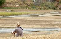
Rivers flowing through the biosphere region, from the highveld catchment areas, include the Selati, Olifants, Blyde, laserie, Sand and Sabie rivers. In the early days all of these rivers were considered to be perennial - that is, they had clear water running in them all year round.
At present, only the deteriorating Blyde and Sabie rivers can be considered perennial. The once mighty Olifants is in its death throes and the others have all become seasonal drainage lines. Gone are most of the clear pools full of hippos, crocodiles and numerous species of fish.
Most clear pools are polluted with agricultural run off and human effluent (if they haven't been 'dragged' to near sterility by portions of stolen shade net). The remainder are filled with sand and mud from increasingly silt-laden floods. Increasingly, useable water is being sourced from underground supplies, further lowering the water table and affecting vegetation.
It is a global problem in all sub-tropical regions but in this region the river catchments are often claimed and allocated as traditional grazing and cropping areas. It is almost too late to wake up to the fact that water is THE controlling factor on the development and survival of our area.
We all need to realise that water is a finite resource, to be managed, and without which we have no future. It is the responsibility of each one of us. How have we caused the death of these rivers?
Healthy Rivers And the of Death

There are numerous dying rivers that have been resuscitated but most examples have involved cleaning up the polluted waterways. In a healthy situation, rain falls on abundant grassland or forest areas.
These areas act as a 'sponge' which soaks up the seasonal rainfall. Such sponge areas are termed 'catchments', which allow the water to seep into streams which feed into the major waterways.
The vegetation holds back most soil particles, providing clear water to run down the rivers throughout the year. There is no need for dams on a perennial river as there is clean water all year round. Catchments are the most valuable areas of any river system and require special protection.
Catchment areas are denuded of vegetation when over-utilised by stock grazing. Ploughing for crop planting destroys the sponge structure of the soil. Mountain forests, cleared of trees, expose the shallow soils, which wash away in heavy rain. In these cases, the sponge effect is destroyed, soil is loosened and the silt-laden water races down to deposit its load of mud in the rivers further down stream.
Because the water runs straight off the land there are sudden floods. These are followed by dry periods because there is no water trapped in sponges to continue the supply. Because of the floods, dams are erected to catch the floodwater. These dams disrupt fish migration and fill with silt.
They are a short-term stop-gap and in many cases aggravate the situation. The river will still fill with silt and die. Certain exotic timber plantations consume more water than indigenous trees.
Where these plantations are in river catchments, silting may occur but more often the rivers run dry. The country requires timber but of a variety that does not use excess water. 'Gum trees' are designed to dry out flooded areas of Australia. In our areas they dry out our catchments.
So What is the Solution?
It is commonly accepted that to fix a problem one should ATTEND TO THE CA-- AND NOT THE EFFECT. 'You will never dig a hole at the bottom of a sand-pile'. Get to the cause of the problem.
Instead of numerous, expensive dams to catch floodwater on all our rivers, we need to be looking at the root cause. The condition of the catchment areas are the cause of our dying rivers.
Timber plantations of the 'greedy' species are being removed with the hope of increased water flow in some rivers. In the case of the silted rivers, it is in most cases too late. Urgent attention needs to be given to the condition of catchment areas. Excessive stock grazing and riverbank cultivation needs to be stopped throughout the area.
With the introduction of electrical power in all areas, the excess and needless removal of trees for firewood needs to end. Grasslands need protection from the abuse of excessive grazing and too frequent and wrongly timed burning.
Legislation has long existed for this protection but these laws are unpoliced by disinterested authorities and constantly ignored by ignorant, uncaring or greedy individuals and communities.
Imagine you were a fish swimming the length of the Olifants river from its source. You would find the water cold and very 'acid' up in the highveld near industry. As you made your way downstream through the mining areas above Steelpoort you would find the water becoming excessively alkaline and polluted.
As you swam further down you would start to choke on the silt running off denuded communal areas and progress would become hampered by sand banks. Arriving at the remaining pools in the lowveld you would find it hard to breath in the water de-oxygenated by algae growing on agricultural run off.
Progress would be hampered by concrete weirs and fish nets strung across the river. Lower down and still facing very muddy water, one would come to almost impassable barriers and shallow, excessively warm water.
Finally, in the Kruger Park, where you thought the river should be comfortable, you are faced with sharing isolated pools full of fermenting droppings from overcrowded hippo and wallowing elephant, where you finally die from lack of oxygen.
The Count Down Has Started
In the past, when miners noticed their canaries showing signs of distress underground, it was a sign to act and get out. These days, when we get the distress signals from species around us we make a note and carry on as normal. We need to take serious note of the indicators still surviving around us and take some action. Water is the limiting factor in this area.
The only clean water remaining is already being pumped from the diminishing and limited Blyde system into the dying Olifants and Klaserie areas, apart from trying to supply Phalaborwa and keep the lower Olifants alive. Developments are going ahead regardless, all based on this limited supply.
We are rapidly running out of water and it is not all due to poor rainfall. We need to urgently address the causes and not the effects while we still have time - otherwise all in this area will soon be history. The fact is - THERE CAN BE NO K2C WITHOUT H2O.
Dave Rushworth
