
The Kruger National Park, a district management area (DMA) will resort under two different municipalities following a decision by the Municipal Demarcation Board in its quest to reduce the number of cross-border municipalities in the country.
The Park previously fell into the Bohlabela District Municipal area, which also comprised the Bushbuckridge and Maruleng Municipal areas. The Demarcation Board proposed that Bushbuckridge Municipality be added to the Ehlanzeni District Municipality in Mpumalanga and the Maruleng Municipality becomes part of the Mopani District in Limpopo.
The Park, south of the Olifants River will be added to Ehlanzeni and north of the river to Mopani. The Board gazetted the proposed changes on October 18. The Board only deals with municipal boundaries while the Department of Provincial and Local Government (DPLG) directs the provincial boundaries. "But the DPLG usually follows the recommendations of the Demarcation Board," says Aluwani Ramagadz, a senior researcher at the Demarcation Board.
The Board's chairman, Vuyo Mlokoti, said the public has 30 days after publication of the notice to object to the Board's re-determination. Bushbuckridge and Maruleng are two of 16 municipalities that the Board identified as cross-border municipalities.
According to Bua News, the DPLG published the Boundary Municipalities Laws Repeal Bill for public comment last month. The Portfolio Committee on provincial and local government is tending to submissions from the affected municipalities. Mlokoti says the main concerns include issues of cultural and historical ties, tribal authorities and service delivery.
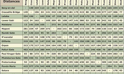 Kruger Park map resource for Kruger Park roads and lodges, as well as gate times, cell phone coverage, self-drive safari maps and Kruger Par...