How Big is Kruger National Park?
The Kruger National Park spans across two of South Africa's 9 provinces, the Limpopo and the Mpumalanga provinces. Kruger National Park covers over 19 455 km2 and is 350 kilometres (217 miles) long from north to south and 60 kilometres (37.2 miles) wide from east to west.
The entire eastern boundary of the reserve is located on the border of Mozambique while its northern border is formed by the Limpopo River and the border of South Africa and Zimbabwe.
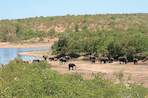
Several major rivers cut through the safari park, including the Letaba, Limpopo, Sabie and Umgwenya (Crocodile) Rivers. The landscape is most plains which are occasionally broken up by the Lebombo mountain range that runs along the Mozambican border from north to south.
Most of the park lies between 260 to 440 metres above sea level with the lowest point being found at the Sabie Gorge and the highest point of 839m being at Khandiwe near Malelane, both towards the south of the safari park.
Pre-History
The area making up the safari park has been occupied by humans for many years and there is evidence of people living in the reserve in the Earlier, Middle and Later Stone Age periods, however; most of the evidence is found along river or flood plains which indicates the habitation was only seasonal.Rock paintings in the over hangs of caves provided evidence of the San people living in the area from about 20 000 years to 150 years. The most popular historical site in the reserve is the Thulamela site, in the north near Punda Maria. Visitors can take guided tours to the location to view the extensive stone walls on the hill top as well as the evidence of iron and gold-smelting.
First European Colonists
The first European travellers moved down from Delagoa Bay in Mozambique into the game reserve in 1725 while in search of trade opportunities. They clashed with the local indigenous warriors when they entered the area just north of the Umgwenya River and were forced to retreat back from where they came.
More than 100 years later the Voortrekkers arrived in the area in 1836 but struggled with malaria and other problems and moved out onto the escarpment where they could descend and graze their cattle in winter and also hunt the abundant game.
